

WASHINGTON D.C.: A 5-Day Plan to See All The Sights
Highlights: White House, Ford’s Theater, Arlington, Pentagon, Smithsonian Museums, FBI Experience, Capital, Mount Vernon.

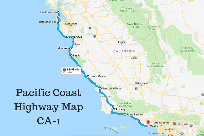
This Big Sur 10-stop itinerary can serve as your guide for an unforgettable day-trip along the California coast. It is one of the most spectacular drives in the United States.

Travel Itinerary
| Stop #1 | Point Lobos State Park |
| Stop #2 | Pebble Beach Golf Links |
| Stop #3 | Soberanes Canyon & Garrapata State Park |
| Stop #4 | Calla Lilly Valley |
| Stop #5 | Garrapata Beach |
| Stop #6 | Rocky Creek Bridge |
| Stop #7 | Bixby Bridge |
| Stop #8 | Big Sur River Inn |
| Stop #9 | Pfeiffer Beach |
| Stop #10 | McWay Falls |
Start in the city Carmel-by-the-Sea and head south along Highway 1 – which is the Pacific Coast Highway (often called the “PCH”).
Heading south will put you on the right side of the road, closer to the coastal scenery. The 10 stops outlined below will take you roughly 5 hours, although it’s only a short 35 miles.
Point Lobos State Park is just 15 minutes from Carmel and is a great site to start your day. Note: there is a $10 entrance fee, while most all others are free.
Stop #2: Golf fan or not, be sure to visit Pebble Beach Golf Links. Home to major PGA golf events, the scenery of this course is absolutely gorgeous.

Follow the signs that guide you on a beautiful drive through several holes.
Stop into the clubhouse for a souvenir, and a tour through a cool Pebble Beach historical museum.

And, if the activity level at the course is fairly low, get a photo taken on the 18th green.

Soberanes Canyon & Garrapata State Park Bluff: this is a 30-minute stop at the most with great ocean views and easy hiking in the bluffs.

Calla Lilly Valley is just 3 minutes further, so no need to get comfortable back in your car as you’ll be stopping again in no time.
Garrapata Beach (which is different from the state park) is practically in the same parking lot as Stop #4. This long stretch of beach is one of the few places along the Big Sur with actual beach access; other stops are mainly rocky cliffs. So take your shoes off, walk the beach, and take in the ocean air.

Rocky Creek Bridge is a popular place people stop, but I’d recommend not stopping too long. Instead, continue just two minutes further to an bigger and more famous bridge.
Bixby Bridge is the most photographed Big Sur spot. And when you see it in person you can understand why. There are two viewpoints on either side of the bridge, depending on if you’re traveling north or south.

Big Sur River Inn is the perfect place to stop for lunch or drink and snack. You can eat at the restaurant tables, or order it to go and have a picnic next to the nearby stream. Chairs are available, which allow you to put them in the water and have your feet in on a hot day.

Pfeiffer Beach is tough to find but worth the effort. Look for mile marker 45.46 right after the Pfeiffer Big Sur State Park Entrance. There’s a turnoff on the coastal side that is hidden by trees. There are no signs that tell you what the turnoff leads to, but it will be a sharp right turn (practically a U-turn) that will take on Sycamore Canyon Road, downhill two miles to Pfeiffer Beach.

$10 entry fee is worth every penny. You’ll enjoy a large, protected cove and views of some neat keyhole rock formations. This was our family’s favorite spot of the day.
McWay Falls (in Julia Pfeiffer Burns State Park) is an 80-foot waterfall that flows directly into the Pacific Ocean. An easy 0.4 mile out-and-back trail takes you to some cool overlooks for a view of the beach below and waterfall.

Can a day get more spectacular than that?!
So, there’s your Big Sur 10-stop itinerary. Of course, there’s other random, unnamed viewpoint stops along the way. So if you have extra time in your day, pull over and check them out for more photo opps.
If back north is where you need to end up, Carmel Beach is a one hour drive from McWay Falls. I recommend getting back there in time to grab a pizza and take it to the beach to watch the sunset.

What do YOU recommend in a Big Sur 10-stop itinerary? Please include your tips in the comments section below!
And, be sure to follow “Whoa, What a View” on social media to see the comments other travelers are leaving there about their favorite parts of Big Sur and surrounding areas.


